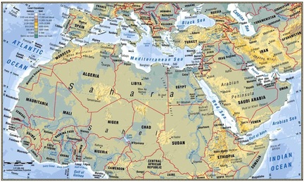
 Today we learned about the physical features of north africa and southwest asia by taking teacher generated notes and creating a physical map of the region. To get notes, click here Steps: 1. students get a blank sheet of paper 2. students label their todals 3. students draw the borders of north africa and south west asia 4. students identify the following terms: 1.Mediterranean sea
2.Red Sea 3.Persian Gulf 4.Arabian Sea 5.Dead Sea 6.Suez Canal 7. Nile R. 8.Tigris R. 9.Euphrates R. 10.Atlas Mountains 11.Strait of Hormuz 12. Sahara Desert 13.Sinai Peninsula 14. Arabian Peninsula
2 Comments
Katalina Pound
1/23/2014 03:33:44 am
What are the items we have to label on the Physical map? please list them here.
Mrs. Moore
1/23/2014 04:20:14 am
See the list above. Identify 1-14 Leave a Reply. |
Categories
All
|
 RSS Feed
